 above: Aug.1943 - during the Second World War, hundreds of workers gather to commemorate the building of the 100,000 th Bren machine gun at the John Inglis factory on Strachan Ave. - the same factory which later went on to build stoves, fridges and dishwashers after the war.
At the top right is seen the north-west rear corner of the remains of the old Toronto Central Prison.
In the distance is the rear of the massive Massey-Harris (later Massey-Ferguson) factory, which faced onto the south-side of King St. W. The railroad tracks run across the photo, just behind the Massey factory. The area where the crowds were standing is now full of condos.
*
below: May, 1941 - women munition factory workers playing baseball, by the south-east corner of the former Toronto Central Prison. The John Inglis plant (which was built in front of (east of) of the prison, along the west side of Strachan Ave., and eventually expanded around the site of the former prison grounds and railyards) manufactured the Bren machine gun. (See here for photos)

 above: same view, Mar.24, 2009, where the baseball game had been played. Surveyors in the distance are measuring the site. The new street at left is Liberty St. East. Just to the left of the photo was where the Toronto Grey and Bruce railroad's (later CP) main line crossed the Great Western's (later Grand Trunk, then Canadian National) line at a sharp angle (just north of the Ex, just west of Strachan). This track (the old narrow-gauge wharf lead) crossed under a bridge at Garrison Rd. (south of Fort York) and under another at Strachan Ave., before sharply turning north-west, crossing the now-CN rail line, and heading into the now-Liberty redevelopment lands. By the late 1980's, I recall this line ended in a stub just before the King St. overpass, near the former Hinde and Dauche [later Irwin Toys] building, which has since been redeveloped into a condo. [Connie Adair wrote in the Jan.7, 2012 National Post about the former Irwin Toys
factory in what is now called "Liberty Village", referring to the
now-condominiumized Toy Factory as being "about 200 years old"! I doubt that!
The Hinde and Dauche building which eventually came to house the Irwin Toy company was not there
in 1812!! That would predate the railroads, the Grange and even Fort York! I
guess "about" in this case can mean "about" a hundred years, give or take, eh?! ]
above: same view, Mar.24, 2009, where the baseball game had been played. Surveyors in the distance are measuring the site. The new street at left is Liberty St. East. Just to the left of the photo was where the Toronto Grey and Bruce railroad's (later CP) main line crossed the Great Western's (later Grand Trunk, then Canadian National) line at a sharp angle (just north of the Ex, just west of Strachan). This track (the old narrow-gauge wharf lead) crossed under a bridge at Garrison Rd. (south of Fort York) and under another at Strachan Ave., before sharply turning north-west, crossing the now-CN rail line, and heading into the now-Liberty redevelopment lands. By the late 1980's, I recall this line ended in a stub just before the King St. overpass, near the former Hinde and Dauche [later Irwin Toys] building, which has since been redeveloped into a condo. [Connie Adair wrote in the Jan.7, 2012 National Post about the former Irwin Toys
factory in what is now called "Liberty Village", referring to the
now-condominiumized Toy Factory as being "about 200 years old"! I doubt that!
The Hinde and Dauche building which eventually came to house the Irwin Toy company was not there
in 1812!! That would predate the railroads, the Grange and even Fort York! I
guess "about" in this case can mean "about" a hundred years, give or take, eh?! ] above: Mar. 24, 2009 - only a small portion, a chapel wing, of the original prison remains, now surrounded by new residential towers where the factories had been. The prison, built in 1873, was set far back along the west side of Strachan Ave. just north of the Grand Trunk railway tracks, north of the Exhibition grounds. The early prisoners here worked on building railway cars for the booming railroad business of the Grand Trunk and Great western.
*
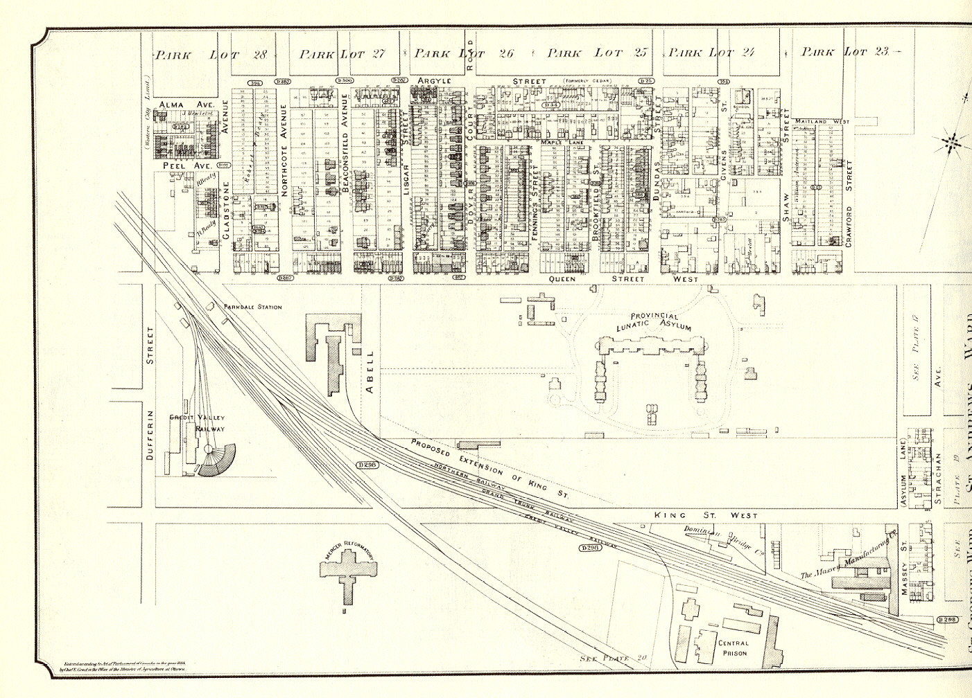
below: Jan.19, 1912 - looking east down King St. W., from the west side of Dufferin St. The rounded top of the Bank of Montreal building is seen at the far right. At the centre left is the Metallic Roofing Company of Canada, which stood on the north-east corner of King and Dufferin; farther east along King, on the left (north) side, can be seen the Pressed Metal Showroom building.
Behind these buildings, to the left, was where the Credit Valley Railroad, another narrow-gauge, had its locomotive roundhouse, with railyards stretching from King to Queen on the east side along Dufferin, and a station at Queen east of Dufferin, south of Gladstone. The roundhouse was closed in 1897 and its equipment moved to the new John St. roundhouse closer downtown on the newly filled shorelands south of Front St.
The south-east corner appears to not yet have been built upon. The Mercer Reformatory building tower can be seen in the far centre right distance, between the two poles.

 above: same view, Mar.25, 2009
*
below: Jan.15, 1942 - #207 Cowan Ave. at the right, looking east from the laneway located south of Queen St. W., which runs between Cowan Ave. and Elm Grove. ave.

 above: Mar.24, 2009 - same view.
*
below: Sept.17, 1915 - looking east down King St. W.; at the bottom right is the south-east corner of King St. and Cowan Ave. Note the streetcar tracks under construction, and how close they are to the sidewalk.

 above: same view, Mar.24, 2009

 above: Mar.24, 2009 - same view.

 above: Mar.24, 2009 - same view.
 below: Oct.10, 1931 - same view, the old firehall and tower were torn down; now the new police station is being built. Note storefronts facing the north side of Queen St. seen at the far right. Note the barrel glass street-lighting fixtures on the poles. The reason that Cowan today is extra wide here south of Queen is due to the requirements for access to the firehouse.

 above: same view, Mar.24, 2009; same building facades line the north side of Queen St. W.

 above: same view, Mar.24, 2009

 above: same view, Apr.10. 2008

 above: same view, Jul.16, 2008. The stone columns along the King St. side are gone.
*
Thanks for visiting Right In Niagara - and send along any memories you may have of old Parkdale.
*
Also see more of this series at Old Parkdale, PART FOUR
*

 above: same view, Mar.24, 2009
*
below: same corner, looking east at King and Cowan, standing farther back. (Dated "12 -11 -03" - pos. 1903, or 1912?)

 above: Mar.24, 2009 - same view.
*
below: Dec.1, 1931 - Looking at the south-west corner of Queen St. W. and Cowan Ave., as the 'new' police station at 1313 Queen St. was being built. This would later be 14 Division. I knew this place well.

 above: Mar.24, 2009 - same view.
*
below: Looking north-west along Cowan Ave. towards Queen St. at the old firehall.
 below: Oct.10, 1931 - same view, the old firehall and tower were torn down; now the new police station is being built. Note storefronts facing the north side of Queen St. seen at the far right. Note the barrel glass street-lighting fixtures on the poles. The reason that Cowan today is extra wide here south of Queen is due to the requirements for access to the firehouse.
 above: same view, Mar.24, 2009; same building facades line the north side of Queen St. W.
*
below: Oct.10, 1931, Looking east along the south side of Queen St. W. towards Cowan Ave., as the work continues on the masonry walls of the police station.

 above: same view, Mar.24, 2009
*
below: Oct.20, 1932 - looking at the south side elevation of the "Kingsley Mansions" which faced along King St. W. This building stands at the north-east corner of King St. and Jameson Ave. (which is at the bottom left)

 above: same view, Apr.10. 2008
*
below: Oct.20, 1942 looking at the "Kingsley Mansions" standing at the north-east corner of King St. and Jameson Ave.

 above: same view, Jul.16, 2008. The stone columns along the King St. side are gone.
*
Thanks for visiting Right In Niagara - and send along any memories you may have of old Parkdale.
*
Also see more of this series at Old Parkdale, PART FOUR
*


1 comment:
Awesome series! I live just north of the Kingsley Mansions and city road construction is underway on Jameson. The photo would be much muddier today. :)
Post a Comment